From the research paper of JAIME E. MASAGCA on the Socio-Political Profile of the City of Legazpi, as a requirement for PM 251, MPM-LGRA, UPD)
Geography
Legazpi City, the capital city of Albay Province, lies on the eastern coast of the Bicol Peninsula and occupies 161.61 square kilometers. On the north of the city is the municipality of Sto. Domingo; is bounded on the east by Albay Gulf; south, by the Province of Sorsogon; and west, by the Municipality of Daraga. It consists of seventy barangays which are divided into urban, composing forty-one political subdivisions, and rural composing twenty-nine rural barangays. 1 Legazpi’s total population is 209,533 as of 2020.2
The City is divided into two districts, namely Legazpi Port District and Albay District, the latter housing the seat of government including the Provincial Government.
Socio-Political History
 |
Legazpi City Hall Building |
 |
Albay Provincial Capito Building |
Legazpi City is not the same as it was centuries or decades ago. It has undergone major changes throughout the years, not only in name nor extent of territory but in terrain, topography, and economic/ infra developments as well.
Most of the central business district of the present Legazpi City had been up to the 1940s mostly swampy areas. The terrain had been greatly altered by reclamation and other developmental projects.
The earliest chronicle of the city’s early existence can be traced to the 13th century, when Datus Balensusa and Dumangsil, two of the ten Bornean Datus led by Datu Puti who fled the oppression of Sultan Makatunaw, are believed to have lingered at Kumintang (Batangas) and Karilaya (Tayabas) and from there gradually penetrated into the fertile valleys of the Bikol Region3 .
Except for the Agtas and Dumagats, the early bikolanos were Malays who settled in the region in the middle of the 13th century.
The first Spanish who came to Legazpi, then known as the barangay of Sawangan, was Capitan Esteban de Manchaca who came in 1587 with a descendant of Dumangsil, Gat Ibal, whom he vanquished by superior arms. The inhabitants were easily converted to the Christian faith by Padre Francisco de Sta. Ana, a Franciscan missionary who built the first chapel made of bamboo and nipa. Sawangan was then designated “Mission de San Gregorio Magno de Sawangan.”.
Sawangan was under the spiritual ministration of Cagsaua until 1605 when it was elevated to a visita regular. The town was made an independent town in 1616 and the provincial capital of the province of Partido Ibalon, the name of which was later changed to Albaybay and shortened to Albay.
For two centuries the capital town was occasionally rocked by the minor eruptions of Mayon Volcano and the attacks of Muslim pirates and the Dutch. On February 1, 1814, the catastrophic eruption of Mayon buried Cagsaua, Budiao, Camalig, and Bulusan, and partially destroyed Sawangan4
This prompted Fr. Pedro Licup to urge the residents of Sawangan to move to Macalaya (now Barangay Taysan. Several years later, Sawangan was restored and called Binanuahan (the dialect for “where a town was once located”). It was made a visita tributaria of Taytay, and the combined towns was named Albay Nuevo (Bagumbayan). The residents of Binanuahan, however, rejected the annexation. No record was available to explain the objections posed by the citizens.
Out of Binanuahan, with Lamba, Rauis (now Barangay Rawis), and Bigaa, the visita of Pueblo Viejo was created through a decree signed on July 17, 1856 by Ramon Montero of the Gobierno Superior de las Islas Filipinas. In another decree Montero named the town as Legazpi, which was inaugurated on October 22 of the same year, to perpetuate the memory of the Adelantado Don Miguel Lopez de Legazpi. Don Lorenzo Hao was the first elective Governadorcillo and Rev. Camilo Abainza was Acting Parish Priest..
The port of Legazpi had served as anchorage of ships sailing to the Nueva Espana (Mexico) in the latter part of the 16th century. In 1873, it was made a port of entry by a Royal Decree earlier issued in Madrid on May 18, 1872, and later promulgated by Governor Juan Alamenos y de Vivar on December 3, 1874.5
Legazpi, Albay, and Daraga were created as an ayuntamiento in 1894 through a decree promulgated by the Spanish Minister of Ultramar. This was again resented by the residents of Daraga6 .
On September 22, 1898, Angel Bascaran y Federic, the Civil Governor of Albay, and the Spanish residents evacuated Albay. Subsequently, a Revolutionary Junta was organized by Don Anacleto Solano who later turned over the command to General Vicente Lukban, General-in-Chief of Operations of the revolutionary government in the southern regions7.
January 23, 1900 marked the start of the American occupation of Legazpi. The American forces arrived and defeated the Sandatahanes led by Generals Vito Belarmino and Jose Ignacio Paua at the Battle of San Rafael Bridge.
The American military government re-established Legazpi, Albay, and Daraga as independent towns. In 1908, the Philippine Assembly again merged the three towns to create the Municipio de Albay which became the capital of the province. Again bitterly opposed, the Philippine Assembly separated the Capital town in 1922.8
On December 12, 1941, the Kimura Detachment of the Japanese Imperial Forces occupied Legazpi while the Philippine American troops were 150 miles away.9 The provisional military government of the Japanese was terminated upon the arrival of the American liberation forces on April 1, 1945.
No other city, perhaps in the Philippines, was proclaimed as a city many times over than Legazpi.10
June 12, 1916 was proclaimed as Charter Day of Legazpi. This pronouncement was discredited by other historical researchers. It was claimed that historical records really showed that Legazpi was made a City as early as 1894 by virtue of a decree, known as the Becerra Law11 , by the Ministro de Ultramar under the Spanish crown. This decree had fused Legazpi, known then as Pueblo Viejo to form the so-called ayuntamiento.12
This status was continued even after the landing of the American forces during the Philippine-American War in 1900.
Legazpi became a city for the second time by virtue of Republic Act No. 306, otherwise known as the Charter of Legazpi, passed on December 15, 1948 to incorporate once
again the town of Daraga with Legazpi and Albay, but again, bitterly opposed, was dissolved on June 8, 1954 by virtue of Republic Act No. 99913 sponsored by Congressman Justino Nuyda, Sr.14
 |
Legazpi Port-Daraga-Sorsogon Junction in the 1950s |
 |
| Albay Cathedral |
 |
| Rizal St. On the left is the old Capitol Building, and the vacant lot on the right is now the site of Divine Word College of Legazpi |
 |
| Independence Day flag raising at the old Penaranda Park, fronting the City Hall and Provincial Capitol Building |
Legazpi City, without the municipality of Daraga, became a city for the third time, by virtue of Republic Act No. 2234 (as amended by Republic Act 5525), which was signed into law on June 12, 1959, at 1:30 in the afternoon by President Garcia aboard RPL Lapu-Lapu.15
Presidential Decree No. 125 issued by President Ferdinand E. Marcos on February 5, 1973, declared Legazpi City anew to include the municipality of Daraga. Under the decree, Legazpi City is to be divided into three districts, namely Daraga, Albay District, and Legazpi Port District. The implementation of Presidential Decree No. 125 was held in abeyance with full implementation plan which also involves a restructuring of local governments.16
At present, Presidential Decree No. 125, creating new territories of Legazpi City seems to have died a natural death. The fact is, only a few of the residents of Legazpi City and the municipality of Daraga are even aware of this decree.
The repeated separation of Daraga from the City of Legazpi is presumably a manifestation of the pride of Daraguenos which no one can understand without first knowing its people’s past.
Historically, the Daraguenos are the descendants of the survivors of Mt. Mayon’s violent eruptions on February 1, 1814 which buried Cagsaua and Budiao, the early settlements in the province. From the National Historical Commission marker at Cagsaua Ruins, the site of the former town of Cagsaua was moved to what is now known as Daraga.
This pride and unity resulting from deliverance from that catastrophe may have been preserved up to the present generation.
While only a stone marker literally separates the municipality of Daraga from Albay District and the rest of Legazpi City, the municipality has even a dialect of its own distinct from its neighboring municipalities.
It is perhaps that unwritten desire to preserve self-identity as a people, rather than for political reasons, that motivates the Daraguenos to maintain its present status as an independent municipality.
As implied or expressly appearing on official records of the City, its local governance structure had also undergone changes like in the rest of the country at different points in history.
 |
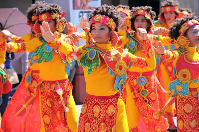
Ibalong Festival. To commemorate Legazpi's rich cultural heritage as part of Tierra de Ibalong |
If the Bikol folk epic, “Ibalong”, claimed by some scholars to be the world’s oldest and longest epic, is to be believed, it can be said that this part of Bicol had its own civilization and a system of governance even during pre-historic times. The Bikol folk epic mentions a system of laws that implies a structure of governance, thus: “With Ibalong rid of wild creatures, Handyong turned to making wise laws and planting the land to linsa and rice. A period of the invention followed: boats, farm tools, weaving looms, claywares, and even a syllabary. Together, the people built tree houses,”17 which social activity can be interpreted as the existence of a “city-state”.
“The Ibalong is not all fancy and imagination alone. In many points, despite its obvious exaggerations, the epic has factual basis.” 18 The places and terminologies mentioned in the Ibalong epic still exist today.
Obviously, it was these self-sufficient communities mentioned in the Bikol folk epic that the Malay migrants and, later, the Spanish explorers found in 1587. While history books had a generalized term for pre-Spanish villages as Barangays, and leaders as Datus, Bikol records make no mention of specific titles of leaders, except those originating from Borneo.
As almost no records exist of the names of local officials during Spanish times, it is likewise presumed that the titles and local governance structure were similar to those in other parts of the country, depending on the territorial classification at a given time. This must be because of the “high degree of centralization in the capital in Manila”19 that no official records are available in the City of Legazpi.
Between the periods of Spanish rule and the American military government, a military junta was established by the local revolutionary forces and briefly lasted from 1898 to 1900 when the American forces defeated local resistance units.
.
The chronological records of the City’s Chief Executives is that beginning in 1900 when the local Chief Executive was called a President. This title continued until the early part of 1931 when the title was changed to Municipal Mayor. The title City Mayor was first used in 1952 during the incumbency of Marcial O. Ranola.
Legazpi City, as it is now known today, had started with a government of its own which if given the chance could have eventually evolved into a system dictated by modernity. But at times, history is not for a people to write, nor destiny for them to chart. In so many instances it is written according to the dictate of factors like a race or civilization that believes in superiority and has impressed on the vanquished its own culture, beliefs, and political doctrines. The imperialist syndrome, under the guise of Christianization and “benevolent assimilation”, had a great influence on the systems of local governance.
This paper will only be half finished as governments will always be subject to changes to keep abreast with the demands of the times. And we are here either as a scholar to such changes, a catalyst of change, or mere spectators as history streams by.
End Notes:
Today, the City of Legazpi, a 1st Class Component City and Capital of the Province of Albay, is hailed as one of the "Most Livable Cities in the Philippines and is the Bicol Region's largest city in terms of population.
According to the 2020 census, it has a population of 209,533, and a Land Area of 161.61 sq. km. . It has 70 Barangays, with 100% classified as Urban and 90% classified as Rural Barangays.
Undoubtedly, it is Bicol's first highly urbanized City.
 |
Hon. Jose Maria "Joey" Sarte Salceda, long time Albay Governor and Congressman of the 2nd District of Albsy |
 |
The boulevard is the favorite place to go for exercise, not only for Legazpenos but also for residents of adjacent towns |
 |
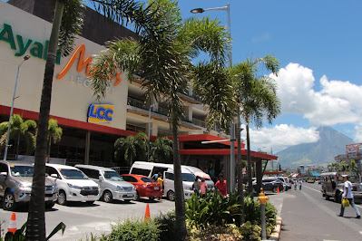
Hon. Noel Ebriega.Risal, City Mayor of Legazpi. He is responsible for the rapid development of the City Ayala Malls Legazpi |
 |
Barangay Lamba |
 |
Albay Cathedral |
 |
| Jose Maria Penaranda, a military engineer and the first Governor of Albay |
 |
Albay Provicial Capitol building |
 |
Divine Word College of Legazpi South Campus. One of the City's center for education that produced many in banking, governance, religious vocations, and business. |
 |
Albay District is not left out of the City's development |
 |
At Embarcadero de Legazpi Boulevard |
 |
Fresh catch from the sea |
 |
Native delicacies for breakfast and snacks |
 |
Baltog, one of the foremost ancient heroes of Tierra de Ibalong |
 |
AND THE CITY'S DEVELOPMENT GOES ON |
6
1 1990 Bicol Situation Report, Department of Tourism, Regional Office No. 5
2 National Statistical Coordination Board/National Statistical Information Center, Legazpi City
3 City Museum, Legazpi City 1
4 City Museum, Legazpi City
5 City Museum, Legazpi City 2
6 City Museum, Legazpi City
7 City Museum, Legazpi City
8 City Museum, Legazpi City
9 City Museum, Legazpi City
10 1990 Bicol Situation Report, Department of Tourism, Region V
11 History of Legazpi City, Legazpi City Tourism Council
12 1990 Bicol Situation Report, Department of Tourism, Region V 3
13 City Museum, Legazpi City
14 Interview with Mrs. Enriqueta B. Ecal, Legazpi City resident
15 City Museum, Legazpi City
16 Legazpi City Info Brief, Legazpi City Museum 4
17 Merito B. Espinas, Ph.D., Ibalong, the Bikol Folk Epic-Fragment (1969)
18 Merito B. Espinas, Ph.D., Ibalong, The Untapped Foundational Component to Bikol Economic Development
19 Proserpina Domingo Tapales, History and Evolution of Philippine Local Government and Administration 5


No comments:
Post a Comment